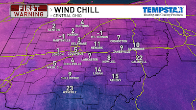
It would be a VERY cold morning for a run today. These are the wind chills at 5AM. Coldest temps of the season, so grab the coat, hat, gloves, and scarf today.

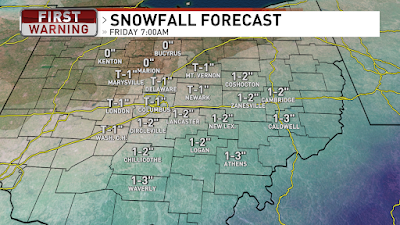
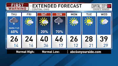
There is an area of low pressure in Kansas moving into Missouri and that will swing through Kentucky today and into West Virginia tonight. Ohio will be on the northern edge of the storm with snow from midday to midnight. Snowfall totals, by Friday morning, for Southern/Southeastern Ohio will be around a couple inches and even more snow near the Ohio River. Central Ohio will see around half an inch, with less to the northwest and more to the southeast. High of 26 today then tonight we will drop into the mid teens with wind chills in the single digits again. Friday we will have a high of 24 with clouds in the morning and then some sun by the afternoon. A few flurries also possible early Friday.

Partly cloudy on Saturday with temps in the teens for the morning then warming up to around 40 for the high. Rain moves in Saturday night and rainy for Sunday morning with a chance of a wintry mix midday/afternoon on the tail end of the rain. So wet & cloudy with highs in the mid 40s on Sunday. Next week will start the week very cold Monday and Tuesday, with highs in the 20s. Partly cloudy as well for Monday and Tuesday. More clouds Wednesday with highs in the upper 30s. Have a good one!
Best,
Andrew Buck Michael
Best,
Andrew Buck Michael


No comments:
Post a Comment